
First GeoAI-Driven Automation Platform
GeoAI-Driven Cloud Platforms for Automatic Vegetation Mapping
An all-in-one GeoAI Cloud platform to rapidly and automatically produce detailed vegetation type and attribute maps using with hyperspectral, LiDAR, and/or digital aerial photogrammetry data.
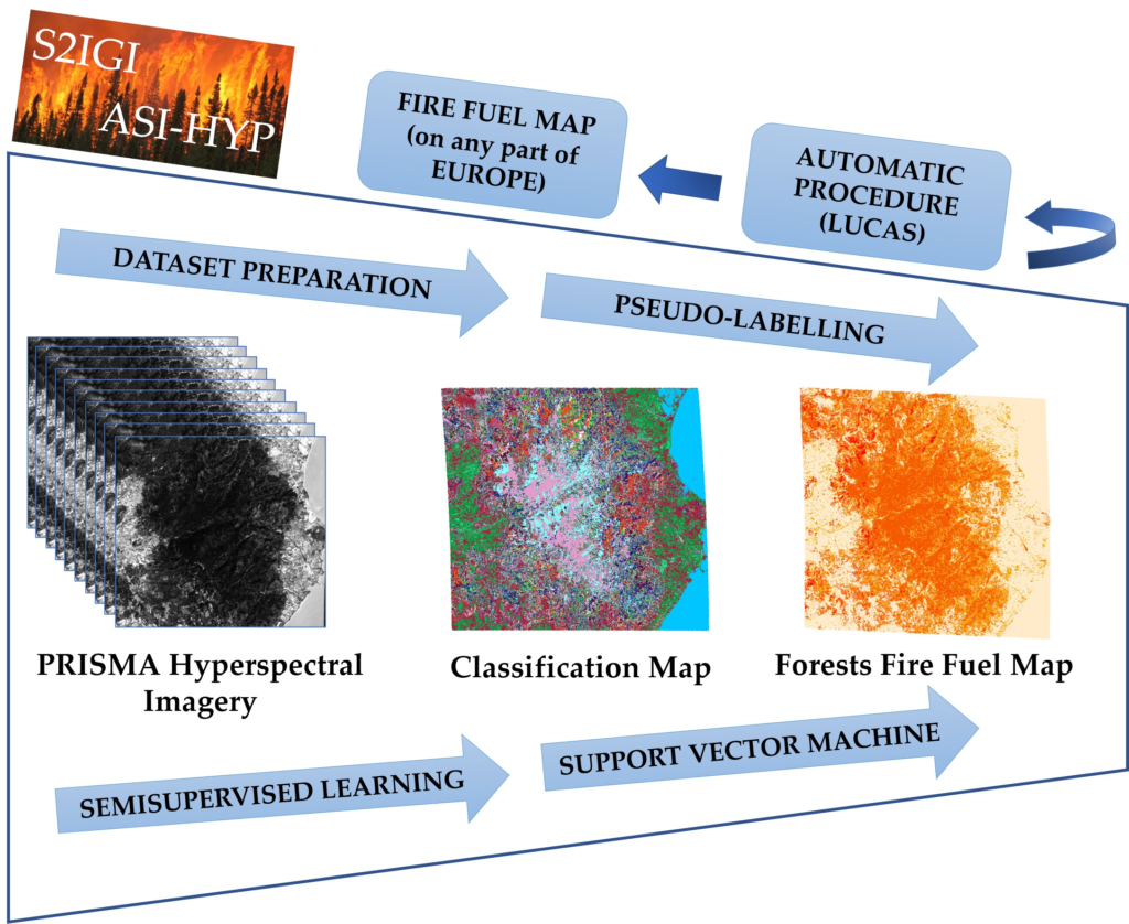
Dr. Riyaaz Uddien Shaik, SGA Research Scientist, has recently developed an open-source automatic machine learning procedure for forest fire fuel mapping using PRISMA hyperspectral imagery. His work was recently published in a March 2022 issue of Remote Sensing journal.
Remote Sensing. 2022, 14, 1264. https://doi.org/10.3390/rs14051264
International Journal of Remote Sensing, 2022, DOI: 10.1080/01431161.2022.2061877
Super GeoAI ‘s recently submitted journal paper demonstrated that quantum machine learning pseudo-labelling and XGBoost hybrid classification can solve feature mapping and classification problems with accuracy within a modest processing time.
A GeoAI-Driven Digital Agriculture Platform for Automating Laborious Manual Observation Associated with Wheat Production
The grain sector is a key driver of Canada’s economic growth, with 20.5 million tonnes of wheat exports in 2017, and $21 billion in exports sales. Many activities associated with wheat production still rely on laborious manual observation, such as (1) wheat yield prediction; (2) early detection of wheat diseases and pests; (3) quantification of wheat disease severity; and (4) post-harvest assessment of wheat kernels. These manual, subjective tasks are costly, unreliable, and inaccurate. Regardless, they are essential to the success of farmers, breeders, researchers, buyers, and producers of wheat alike.
This project brings together numerous digital technologies, agri-food companies, and academic institutions to develop a novel GeoAI-driven smart farm platform, reducing manual observational requirements and increasing competitiveness, productivity and efficiency for Canada’s agricultural producers.
A GeoAI-driven mobile application to count the number of wheat heads and wheat kernels in the image.
An Integrated 2D and 3D Web-Based GeoAI Platform
SGA Web GIS is an integrated 2D and 3D Web-based GeoAI platform that integrates geospatial, AI, big data, cloud computing, and UAV technologies to help people collect, manage, analyze, and visualize large amounts of spatial data in a web-based platform. As our GeoAI technology can process spatial big data efficiently, the cost to maintain the system is much lower than current innovations, improving affordability for the end-user.
Our projects include (1) Development of a web-based GeoAI framework to automatically detect, map, analyze, and predict community-level Covid-19 spread in real-time. (2) Development of a GeoAI-based Park Ecosystem Database
A web GIS to visualize how COVID-19 spread globally in real time from January 22 to today. Please click here to view live. A new version is upcoming.