
SupeGeoAI COVID-19 Global
Please note that this is a beta desktop version. We are collaborating with 51.ca to develop a mobile Canadian version. Please visit https://info.51.ca for more COVID-19 information.
1. A web GIS to Visualize, Monitor and Predict COVID-19 Spread in Real Time!
Click here to view the Video.
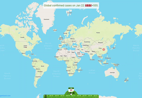
The following web geographic information system (GIS) shows how COVID-19 spread globally in real time from January 22 to today using the data provided by Johns Hopkins University. Rewind to the beginning and click the “play” button (see below) to show how the coronavirus spread from January 22 to today. Click guide to get you know what the map can do. Click Here to go to full screen mode. This is a beta desktop version and it works well only on desktop computer. A mobile version is coming soon. Click Here to view the video at YouTube. The map might load slowly, but it will respond quickly after its open.
Data Source as Below: ESRI COVID-19 GIS Hub
COVID-19 in US
1. Total Cases Trends
Click Cumulative cases, New cases, or Cumulative Deaths in the legend, to turn on or turn off them in the chart.
2. Confirmed Cases by State
2.1 Top 15 Confirmed COVID-19 Cases in States in the U.S.
Click Confirmed or Deaths in the legend to turn on or turn off click on/off in the chart.
2.2 Map: Confirmed COVID-19 Cases by States in the U.S.
Move your mouse over the map and legend to popup detailed information.
2.3 Table: Confirmed COVID-19 Cases by States in the U.S.
To see county data within a state, click on the plus sign beside the state.